Scientists create 360-degree images of Hawaii coral reefs
HONOLULU — Alongside the lush and steep windward coast of the Hawaii island of Oahu researchers are creating images of coral reefs that are in danger of dying because of warm ocean waters.

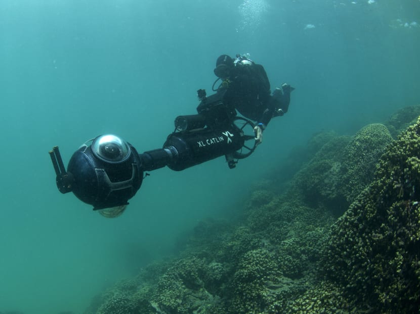
In this Thursday, Aug. 13, 2015 photo provided by XL Catlin Seaview Survey, Dr. Manuel Gonzalez-Rivero, a postdoctoral research fellow at the The University of Queensland and a member of the survey crew, uses a 360-degree underwater camera to photograph coral reefs in Kaneohe Bay off the east coast of Oahu, Hawaii. Photo: AP
HONOLULU — Alongside the lush and steep windward coast of the Hawaii island of Oahu researchers are creating images of coral reefs that are in danger of dying because of warm ocean waters.
They are taking high-definition 360-degree panoramic images of the reefs and using them to monitor and study the health of corals over time. Scientists working with the team say they are concerned about how much coral off the coast of Hawaii already is beginning to bleach, especially because it's the second such event in two years.
Coral bleaching occurs when ocean water temperatures rise and cause the coral to lose key nutrients, turning the normally colourful organism white. If bleaching recurs or is severe, experts say the coral will die.
Reefs off the coasts of the Hawaiian islands suffered a rare bleaching event in 2014, and experts say when corals don't have time to recover from one bleaching they are less likely to survive subsequent events.
Extensive coral bleaching is expected again this year in Hawaii because of record hot weather in the region, a strong El Nino weather pattern and what scientists call "the blob," a large area of hot water not directly linked to El Nino that is moving westward from the United States mainland.
"Unfortunately, from now on the extra heat is going to be quite damaging, and this is where the mortality of the corals goes up," said Professor Ove Hoegh-Guldberg, director of the Global Change Institute at the University of Queensland and the research team's chief scientist.
The Hawaii reef mapping is part of a larger project by the XL Catlin Seaview Survey research team to make thousands of images of reef around the world. Researchers are trying to understand why certain species of coral are more susceptible to bleaching than others, and they hope to find organisms that can adapt to warmer waters and remain healthy.
The researchers use GPS tags and facial recognition technology to help identify and organise individual reef systems. As part of the project, the survey team has partnered with Google and uploads the images to Google Street View, allowing people to explore the underwater ecosystem via the Internet.
The Seaview Survey has already gathered data from other reefs including those in the Maldives, Mexico, Indonesia and Australia. The team had baseline images of a section of the Great Barrier Reef that was later damaged by a typhoon. The crew went back to capture the damage, giving researchers a clear view of the loss involved with a major storm.
Dr Manuel Gonzalez-Rivero, a postdoctoral research fellow at the University of Queensland and a member of the survey crew, said the team uses similar technology to what Facebook uses to recognise people in photos.
"We apply that to coral," he said. "We train it in a way so that the machine starts recognising different types of corals, and it can process about 500,000 images in about a week."
He said that's about 30 to 50 times faster than the traditional method of photographing and processing images of coral for research, allowing them to capture larger areas of all the reefs they visit.
Researchers were out on Hawaii's Kaneohe Bay near the famed hat-shaped island of Mokolii last week. Along with the survey team, three scientists went to two different locations about a mile off shore on the north edge of a reef that runs along a sandbar. While the Seaview Survey crew dived with a specially designed camera and sea scooter system, which houses three wide angle lenses pointed in different directions, the scientists snorkeled and inspected the condition of the organisms near the surface.
"What sort of surprised me is how many corals have already started to bleach," said Dr Malia Chow, National Oceanic and Atmospheric Administration's superintendent of the Hawaiian Islands Humpback Whale National Marine Sanctuary, who was with the survey crew last week. AP


