NTU studying ways to allow drones to fly safely in Singapore
SINGAPORE — With drones gaining popularity and some companies using them in operations, researchers here are starting work on how to manage what could be an increasingly congested airspace in a few years.

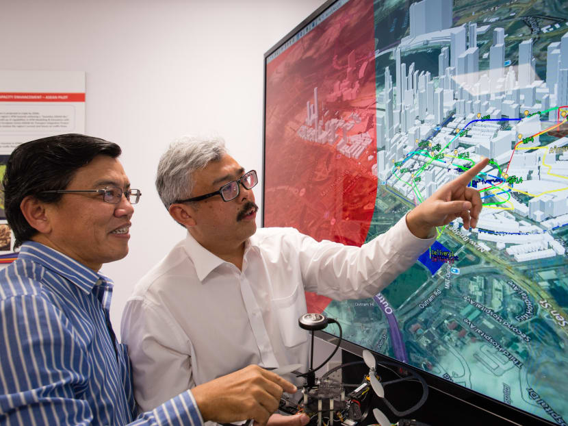
NTU Professor Low Kin Huat (left) and Air Traffic Management Research Institute’s Deputy Director Mr Mohamed Faisal Bin Mohamed Salleh discussing an NTU-developed air traffic simulation, which takes into account various solutions to enable safe and efficient drone travel in Singapore. Photo: NTU
SINGAPORE — With drones gaining popularity and some companies using them in operations, researchers here are starting work on how to manage what could be an increasingly congested airspace in a few years.
Spearheaded by the Air Traffic Management Research Institute at Nanyang Technological University (NTU), the researchers are looking into technologies and ways to create a traffic management system, much like how cars on the roads have to abide by traffic lights and lanes.
As part of the four-year research project, the institute — jointly set up by NTU and the Civil Aviation Authority of Singapore (CAAS) — will look at how to designate flight paths, avoid collisions and prevent unauthorised access to restricted zones for unmanned aerial vehicles (UAVs), or drones.
One way would be to set up coordinating stations to track these drones, schedule traffic flow and monitor their speeds, while one central station oversees them.
To find the best way to minimise traffic congestions, these situations will be tested using computer simulations and software.
The institute’s senior research fellow, Mr Mohamed Faisal Mohamed Salleh, who is leading the project, told the media at a briefing on Wednesday (Dec 28): “We are looking at a dynamic configuration of the urban airspace, depending on the demand and capacity.
“You could allow UAVs to fly directly from point to point if there’s hardly any ground traffic, but in peak periods where there is a lot of demand in the network, a more structured flight path could switch into place.”
Designated take-off and landing spots such as open fields may be marked out within residential, recreational and industrial zones in various towns in Singapore — in Ang Mo Kio or Jurong, for instance. The rooftops of buildings and public housing blocks may also act as emergency landing sites to minimise risks to the public.
Another area to explore would be geofencing, or setting up virtual fences where drones are automatically routed around restricted airspace, and their position may be detected via radar systems or GPS.
The team will also be studying collision-detection techniques, where drones are equipped with sensors to detect and avoid flying into other drones, and also explore other strategies such as airspace being divided into air blocks to dictate whether it is safe for a drone to fly through each block.
Mr Faisal added: “Just like on the roads, where you have multiple road users, like e-scooters, cyclists, pedestrians, on one track — how do you put a system in place to regulate the use? (Similarly), in an urban airspace with multiple drones operating, the aim of this programme is to ensure drones can operate safely and efficiently, and to manage them in terms of capacity and demand.”
The project is in its first phase of conceptual design and software simulation, to be completed by the end of next year. This will be followed by test-bedding the solutions in 2018, potentially in areas such as Tuas.
In May last year, laws were passed in Parliament to assuage concerns over matters of safety, security and privacy surrounding unmanned aerial vehicles, such as the need for permits to fly drones above 7kg, or within a 5km radius of an aerodrome.
Transport analyst Park Byung Joon said that designing this new traffic management system may prove to be “immensely complex”, especially if demand rises in the future. “Tracking these (drones) would be a problem, because they typically fly very low, so if we use radars, they’d have to be very powerful ... But we are still in the early stages and we need to do a lot more research in this area,” he said.
Outside of Singapore, similar intiatives are being undertaken, such as the unmanned aircraft systems traffic management research effort led by United States space agency Nasa, which focuses on developing a low-altitude airspace management system for drones.
Likewise, Pan-European telecoms provider Vodafone has expressed interest in managing drone traffic in Europe by using its mobile network. For instance, consumer drones may be required to register and insert a SIM card, and the network could then be used to enable communication between drones to avoid collisions.


