Atlantic ocean is dry, dusty and struggling to spit out storms
BOSTON — It might be hard to think of an ocean as dry and dusty. Right now, those are the conditions over a large part of the Atlantic where hurricanes often form.
BOSTON — It might be hard to think of an ocean as dry and dusty. Right now, those are the conditions over a large part of the Atlantic where hurricanes often form.
The dust, coming off Africa, is just one item on a list of things that are making the Atlantic particularly inhospitable to large tropical systems. Cool water and high wind shear, which can tear hurricanes apart, are also well represented.
"It is looking so very harsh in the Atlantic," said Dr Phil Klotzbach, lead author of Colorado State University's seasonal hurricane forecast. "Overall, it's not conducive for hurricane formation."
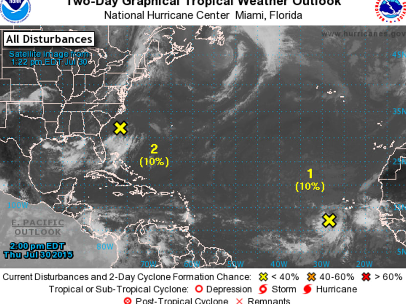
The US National Hurricane Center yesterday (July 30) was tracking the buds of two storms in the basin. One, just south of the Cape Verde Islands, had a 30 per cent chance of developing in the next five days, but those odds were dropped Friday to 10 per cent. The other, near Georgia, disappeared from the centre's map.
The area off Cape Verde is where most big hurricanes are born in August and September, the heart of the six-month season. In a normal year, having the seeds of a storm there would give forecasters from the Caribbean islands to the Atlantic coast of North America reason to worry.
This is not a normal year.
ATLANTIC ‘CLOSED’
"In general, the Atlantic will mostly be closed for business for hurricanes, with only a few fleeting opportunities for dangerous hurricanes to form," said Dr Jeff Masters, co- founder of Weather Underground in Ann Arbor, Michigan.
The further west the Cape Verde system goes, "the more hostile the conditions get", he said.
Some stations across the Atlantic are reporting the most dust in 10 to 15 years, said Dr Klotzbach.
Then there is the cool water and the shear. Hurricanes thrive on warm seas and weaken as they reach colder temperatures. Shear is when the winds at different altitudes blow at varying speeds or directions.
It is like the Atlantic is "booby-trapped", said Dr Dan Kottlowski, a meteorologist at AccuWeather in State College, Pennsylvania.
A good example of what shear can do was demonstrated in the cluster of thunderstorms off Georgia. Basically, the shear, which was blowing at about 72km per hour in places, knocked the head off the system's shoulders.
The biggest threat in the entire ocean may be a large storm that developed off Bermuda a few days ago and is gaining power in the North Atlantic off the coast of Newfoundland.
A buoy off the Canadian province recorded waves as high as 4.27m yesterday, according to the National Data Buoy Center at Stennis Space Center in Mississippi.
While not a hurricane, it has winds of 50mph to 60mph and is on a course that will probably take it near Ireland and the UK tomorrow and Sunday, Dr Kottlowski said.
Just another glorious summer weekend in Ireland. BLOOMBERG


