Explainer: What S'pore, M'sia are arguing about regarding Seletar Airport's Instrument Landing System
SINGAPORE — Singapore plans to use the Instrument Landing Systems (ILS) at Seletar Airport from Jan 3 next year. This has become a subject of dispute, with Malaysia saying that the flight path used by the system will encroach into its airspace.
 at Seletar Airport from Jan 3, 2019.")
Singapore will enforce the use of the Instrument Landing System (ILS) at Seletar Airport from Jan 3, 2019.

SINGAPORE — Singapore plans to use the Instrument Landing Systems (ILS) at Seletar Airport from Jan 3 next year. This has become a subject of dispute, with Malaysia saying that the flight path used by the system will encroach into its airspace.
It also said that planes heading to the airport will have to fly over the Johor Baru town of Pasir Gudang, potentially affecting the town’s development as height restrictions on buildings and other structures will be imposed.
WHAT SYSTEM IS THIS AND WHY USE IT?
For the past decades, pilots flying to Seletar Airport have been using visual approaches to get to and land on the runway. This means they have to look out for on-the-ground structures along their path and manoeuvre around them if need be. Changi Airport has been using the ILS.
The ILS enhances operational flexibility, especially during adverse weather conditions, as compared to operating aircraft using a visual approach. It guides planes to stay on a specific path of descent and tells them the descending angle. Imagine it as a tool that guides cars entering a car park — which lanes to use and where to park.
Read also
WHAT GOES INTO PREPARING THE SYSTEM?
When Singapore designs flight procedures, it typically consults other parties who may be affected.
It will also conduct an assessment of the structures below the flight’s path of descent to ensure obstacles will not disrupt the path, and find out if there are upcoming developments.
So, since it manages the Southern Johor airspace, Singapore has consulted Malaysia, but the latter claimed that the consultation did not take place until two months ago.
However, Singapore is saying that it first informed its neighbour of the ILS procedures on Dec 5 in 2017. Singapore had repeatedly sought Malaysia’s feedback thereafter. On Aug 7, the authorities met their Malaysian counterparts to provide more details on the ILS and, once again, asked for feedback. An email was then sent on Aug 15 to follow up, asking for a response by Aug 27. There was no reply from Malaysia.
It was only on Nov 29 that Malaysia raised substantive concerns, which were addressed by Singapore. It also told Malaysia of its intention to publish the ILS procedures on Dec 1.
The ILS procedures are not cast in stone. If there are plans for upcoming developments in the Johor Baru town of Pasir Gudang, various parties can discuss about it and the ILS procedures could be changed.
FACTS AND FIGURES
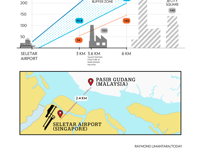
- Distance from Seletar Airport to the coast of Pasir Gudang is 2.4km.
- Starting point of descent to Seletar Airport is 20km away from the runway.
- Flight path over Southern Johor has been used for decades.
HOW ACCURATE ARE POINTS MADE IN MALAYSIA’S VIDEO?
On Tuesday (Dec 11), Malaysia’s Transport Minister Anthony Loke posted a video on his Facebook page that is more than a minute long, and it raised several points to illustrate why there is objection to the ILS procedures being rolled out at Seletar Airport.
However, Singapore’s Transport Minister Khaw Boon Wan told reporters on Wednesday that the video “contains a few inaccuracies”.
Inaccuracy 1
What the video says: Structures 3km away from Seletar Airport cannot be built higher than 54m, while structures 6km away from Seletar cannot be built more than 145m. A mobile crane at 103m will breach the height limits and there are also other tall buildings in Johor.
What the facts are: The ILS procedures were designed in line with international standards and taking into account Pasir Gudang’s existing structures.
Under the ILS procedures, flights will use a glide path when they descend. Below this glide path is the Obstacle Assessment Surface, or to put it simply, a safety height buffer that extends from the on-the-ground structure to the glide path. Structures should not penetrate this buffer and the height restrictions vary along the path of descent.
The safety height buffer at the 3km mark is 93.8m, and at the 6km mark, it is 193.1m. This means the height of structures should not exceed those figures.
Right now, the tallest structure in Pasir Gudang is 105m tall and is located 3.6km from Seletar Airport. So, it falls under the height restriction. These height restrictions can be further adjusted if required.
Inaccuracy 2
What the video says: The flight path prevents the construction of tall buildings over Pasir Gudang.
What the facts are: So far, developments in Pasir Gudang have not been constrained by the existing flight path. Malaysia would, in the past, inform Singapore of new developments. Singapore would then assess and adjust procedures as necessary.
As of now, Singapore has not been informed of any upcoming developments that would significantly affect the flight path for flights going to Seletar Airport.
To ensure aviation safety, Malaysia is required under international guidelines to provide early notification of upcoming developments.
Inaccuracy 3
What the video says: Pasir Gudang Port will be subjected to higher risks and multiple restrictions.
What the facts are: Activities at the port and in the sea will not be affected by the existing flight path. There has been a standard procedure for flights to be held back while tall vessels cross the Straits of Johor.
Inaccuracy 4
What the video says: Previously, Seletar Airport did not use ILS. Pilots can manoeuvre around obstacles and no height regulation is required around flight path area. With ILS, it will be compulsory to impose height restrictions.
What the facts are: Just because pilots use ILS does not mean they do not have full control of the planes. They still do, meaning they can manually intervene, if necessary.
Under international standards, it is also a requirement to mitigate the impact of tall buildings on aviation safety. This is regardless of whether or not pilots use the ILS or visual procedures.
Inaccuracy 5
What the video says: The existing flight path affects development in various areas, from Pasir Gudang up north to Ayer Tawar and almost to Kota Tinggi.
What the facts are: The further an area is from Seletar Airport, the higher is the height limit. Therefore, there will be less impact on ground developments. For instance, planes will be flying at a height of 1km at Ayer Tawar.
Inaccuracy 6
What the video says: Mr Loke said that Malaysia is not against Seletar Airport, “but as far as the descending flight path is concerned, it cannot be over Pasir Gudang”. He urged Singapore to withdraw the ILS and to amend the flight path for entry from the southern end.
What the facts are: Singapore already told its neighbour that it will require instrument flight procedures for flights coming into Seletar Airport from the north and south. This is necessary as wind blows from a north-easterly direction for the first half of the year, and south-westerly in the second half of the year.
The ILS procedures will be used for flights coming from the north and, as such, there is a need for instrument flight approaches for planes arriving from the south.
Clarification: The previous version of this story stated that the ILS procedures are already used for flights coming from the north. CAAS has clarified that the procedures are not in use yet.
Stay in the know. Anytime. Anywhere.

Subscribe to get daily news updates, insights and must reads delivered straight to your inbox.
By clicking subscribe, I agree for my personal data to be used to send me TODAY newsletters, promotional offers and for research and analysis.