Plans for underground road network around CBD scrapped
SINGAPORE — The Government has scrapped decades-old plans to build a multi-billion-dollar underground road network that would span 30km around the fringe of the city centre and cut across swathes of prime land.

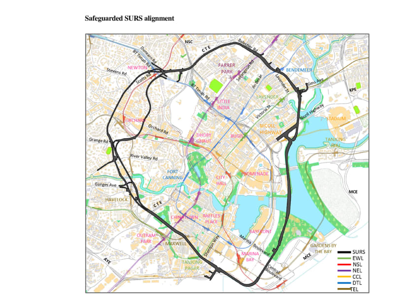
Map showing plans for 30km underground road network surrounding the Central Business District (CBD) that have been scrapped. Photo: LTA-URA
SINGAPORE — The Government has scrapped decades-old plans to build a multi-billion-dollar underground road network that would span 30km around the fringe of the city centre and cut across swathes of prime land.
The move would lift restrictions that were imposed for more than two decades, and give land owners more flexibility in their development plans, said the Land Transport Authority (LTA) and the Urban Redevelopment Authority (URA) in a joint statement on Tuesday (Aug 29).
For instance, the land owners are now free to explore options to drill underground or build taller buildings.
Property analysts interviewed said the Government’s decision would give urban planners greater leeway in the longer term, but they do not expect any immediate impact, particularly for the areas which are densely built-up.
Land preserved for the Singapore Underground Road System (Surs) will be “de-safeguarded” with effect from Tuesday, as the Republic moves towards a car-lite society, the authorities said.
There are 295 properties — comprising 257 private properties and 38 state properties — that sit on the land, an LTA spokesperson told TODAY. These consist mainly of condominiums, a few shopping centres, and Government-operated buildings.
The proposed alignment of the Surs does not cut across any public housing estates. The Surs was first conceptualised in the late 1980s as an underground arterial ring road system around the city fringes.
The land along the Surs’ planned alignment was first safeguarded in 1993. What it meant for affected land owners, for example, was that they had to make engineering provisions to ensure that their structures will remain sound in the event the Government develops the subterranean spaces under their land.
The Government’s 1996 White Paper on Land Transport estimated that the Surs would cost some S$5 billion to build, and improve city traffic by 40 per cent.
The looped area runs through the Central Business District (CBD) at Marina Bay, Tanjong Pagar and Maxwell, and spans to the Orchard shopping district along Cairnhill Road and Scotts Road. It also sits under parts of the Central Expressway and the Marina Costal Expressway, and lies along the coastal stretch along Republic Boulevard.
Explaining why the Surs was “no longer needed”, the LTA and the URA pointed to enhancements to Singapore’s public transport network and changes in its land-use policies.
They said: “The city centre is well-served by a comprehensive public transport network and the full opening of the Downtown Line on Oct 21 this year will further improve public transport connectivity, especially for commuters travelling from the north-western and eastern regions of the island to the CBD and Marina Bay areas.”
More than 90 per cent of developments in the CBD will be within a five-minute walk to an MRT station by 2030, when the rail network becomes 360 km long after the completion of Circle Line Stage 6 and the Thomson-East Coast Line, among other new lines.
The LTA and URA also noted that the need to travel in and out of the city centre has been reduced. “The Government has also been growing more commercial centres in different regions outside the city. This brings employment and amenities closer to homes,” they said.
PROJECT WAS PROPOSED IN 1980s
The idea to have a subterranean road network in the city centre was conceptualised in the 1980s, with land set aside by the authorities through a process called “safeguarding” in 1993.
The 1996 White Paper on Land Transport gave the first glimpse of the proposed project, dubbed Singapore Underground Road System (Surs). It was envisioned to have two concentric ring roads each 15km long underground that would run under the city centre, encircling streets like Orchard Road, Scotts Road, Lavender Street, Nicoll Highway, Shenton Way, and the Marina South area, where the extension of the Central Business District was coming up.
At that time, the project made provisions for eight interchanges and 33 entrances and exits. Land planners estimated the Surs to allow city traffic to increase 40 per cent, although it was to have cost some S$5 billion alone to build.
News reports said the Surs, if implemented, would have to be built in phases, over at least 15 years, considering the density of the city centre. The cost of operating the Surs was projected to be S$80 million annually, which would have worked out to S$30 per pass to recover.
In an interview in 1999, then chief of the Land Transport Authority (LTA) Han Eng Juan said the Surs idea “(had) not been thrown out of the window and is part of our long-term plan”.
He added that it was, however, not the priority at that time. A new rail line was preferred to spend the budget on.
In the most recent Land Transport Masterplan in 2013, it appeared as if the Surs could be expanded.
The report said: “With new commercial and residential developments planned for the Marina South area and the new southern waterfront city area that will extend from Marina Bay along the waterfront from Keppel Channel, through Telok Blangah to Pasir Panjang Terminal, we are now studying how Surs can serve these new developments in the long term.
As we continue to monitor the pace of development in the Marina South area and the new southern waterfront city, we will review the implementation plans for Surs.” Other cities have turned to subterranean roads to free up surface space and make urban areas more liveable.
Examples of these cities include Brussels, Stockholm, Madrid, Paris, Hamburg and Boston.


