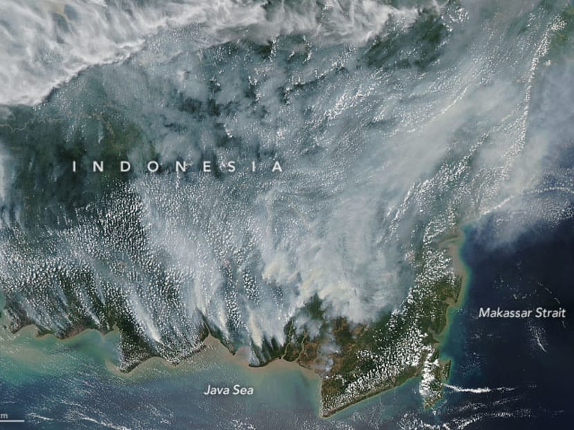
Nasa’s latest satellite photo draws similarities to 2015 haze crisis
KUALA LUMPUR — The National Aeronautics and Space Administration (Nasa) has released a satellite photo of smoke billowing from Kalimantan, Indonesia that has similarities to the 2015 air pollution crisis.
KUALA LUMPUR — The National Aeronautics and Space Administration (Nasa) has released a satellite photo of smoke billowing from Kalimantan, Indonesia that has similarities to the 2015 air pollution crisis.
The image captured on Sunday (Sept 15) supports the findings by Nasa Goddard Institute for Space Studies scientist Robert Field that the current condition is nearing the 2015 haze condition peak.
Mr Field, who has been tracking the progression of the past fire seasons in Indonesia said the country is heading toward another “major event”.
“They are really in the thick of another major event now. It is reminiscent of 2015, though the buildup of smoke started few weeks later this year because of rains in mid-August,” said Mr Field, who is working on a project to better understand how various meteorological variables affect the likelihood of vegetation burning.
As part of that effort, he is also working on a Nasa applied science project to integrate more satellite-based precipitation measurements into a fire danger monitoring system used by the Indonesian Meteorological, Climatological and Geophysical Agency.
“The fire counts from MODIS (Moderate Resolution Imaging Spectroradiometer) and VIIRS (Visible Infrared Imaging Radiometre Suite) satellites have not been quite as high as they were in 2015 because of the late start, but the day-to-day increases in activity are now comparable to 2015,” said Mr Field.
However, he said, it is worth keeping in mind that many of these fires are burning underground or in areas with such thick smoke that satellites cannot detect them.
According to Nasa, many of the fires are burning in Kalimantan, which is known for having extensive peat deposits, which are made up of a mixture of partly decayed plant materials formed in wetlands.
Its satellites have also detected evidence of fires burning in this region throughout much of August, but the number and intensity of the fires increased in the first week of September.
The haze incident in 2015 was deemed an air pollution crisis affecting several countries in Southeast Asia, including Brunei, Indonesia, Malaysia, Singapore, southern Thailand, Vietnam, Cambodia and the Philippines.
This was the second most severe haze incident after the 1997 incident which triggered the inking of the Asean Agreement on Transboundary Haze Pollution in 2002. MALAY MAIL


